
 Deutsch
 Español
 Français
 Italiano
 Nederlands
 English
Sale!
Middleborough, MA, Mass Purchases of Land in the 1600s (includes Lakeville) New
$11.61
100
Description
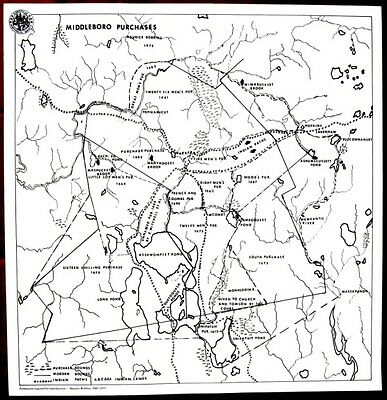
This “Middleboro Purchases” map is a reprint of the map prepared by archaeologist Maurice Robbins, PhD in 1973. It shows the bounds of land purchases during the latter part of the 1600s in the
Middleborough
/ Lakeville area. Included are the Sixteen Shilling Purchase in 1675, the Twenty Six Mens Purchase in 1661, etc. as well as old Indian Paths. This new map measures 18 inches wide and 18.5 inches high.